Version

Navigating Map Content Using Overview Plus Detail Pane

Purpose

This topic provides information how to use the xamOverviewPlusDetailPane™ control to navigate map content in the XamGeographicMap™ control.

Required background

The following table lists the topics required as a prerequisite to understanding this topic.

Topic Purpose

This topic provides an overview of key features in the XamGeographicMap control.

This topic provides conceptual information about navigating map content in the XamGeographicMap control as well as all supported navigation features of the control.

Displaying Map Overview Pane

Introduction

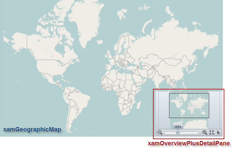
In the XamGeographicMap control, an overview of map content is represented by the xamOverviewPlusDetailPane control. This control provides a thumbnail of the world as well as navigation functionalities.

Preview

The following is a preview of the xamOverviewPlusDetailPane control with an overview of the XamGeographicMap control displaying the world.

GeographicMap Navigating Map Content Using Overview Plus Detail Pane 1.png

Example

The following code demonstrates how to display the xamOverviewPlusDetailPane control in the lower right corner of the XamGeographicMap control.

Note
Note:

More layout locations of OPD control can be achieved by setting a style with custom margins for the xamOverviewPlusDetailPane control to the OverviewPlusDetailPaneStyle property of map control.

In XAML:

<ig:XamGeographicMap x:Name="map"
 OverviewPlusDetailPaneVisibility="Visible"
 OverviewPlusDetailPaneHorizontalAlignment="Right"
 OverviewPlusDetailPaneVerticalAlignment="Bottom">
</ig:XamGeographicMap>

In Visual Basic:

Dim map As New XamGeographicMap()
map.OverviewPlusDetailPaneHorizontalAlignment = HorizontalAlignment.Right
map.OverviewPlusDetailPaneVerticalAlignment = VerticalAlignment.Bottom
map.OverviewPlusDetailPaneVisibility = Visibility.Visible

In C#:

XamGeographicMap map = new XamGeographicMap();
map.OverviewPlusDetailPaneHorizontalAlignment = HorizontalAlignment.Right;
map.OverviewPlusDetailPaneVerticalAlignment = VerticalAlignment.Bottom;
map.OverviewPlusDetailPaneVisibility = Visibility.Visible;

Changing Thumbnail Image in Map Overview Pane

Introduction

The XamGeographicMap control displays a preview of the world as a static image in the xamOverviewPlusDetailPane control. The default image was captured from the geographic imagery provided by the Open Street Maps service. For more information on the geographic imagery, please refer to the Using Geographic Imagery topic.

Note
Note:

At present, the XamGeographicMap control does not support a preview of geographic series in the xamOverviewPlusDetailPane control. However, you can capture a screenshot of the geographic series rendered in the XamGeographicMap control and used as a thumbnail image in the xamOverviewPlusDetailPane control.

Preview

The following is a preview of the XamGeographicMap control with overridden style for the xamOverviewPlusDetailPane control that provides a custom static image as thumbnail of the map content.

GeographicMap Navigating Map Content Using Overview Plus Detail Pane 2.png

Example

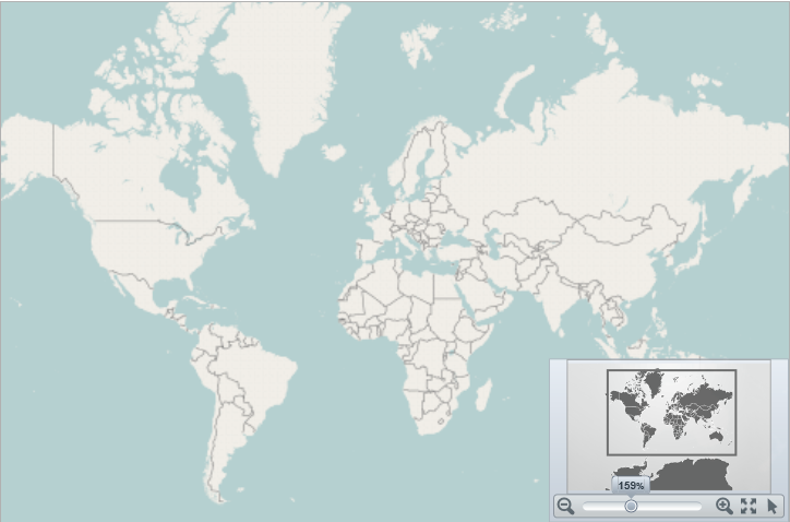
Use the OverviewPlusDetailPaneStyle property for the purpose of changing thumbnail of the map content as well as other properties of the xamOverviewPlusDetailPane control.

Note
Note:

In order to fill content the xamOverviewPlusDetailPane control, the thumbnail image should have 16:10 aspect ratio between width and height (e.g. 320 x 200 pixels).

The following code demonstrates how to apply a style of the xamOverviewPlusDetailPane type with desired thumbnail image to the XamGeographicMap control.

In XAML:

<ig:XamGeographicMap.OverviewPlusDetailPaneStyle>
    <Style TargetType="ig:XamOverviewPlusDetailPane" >
        <Setter Property="ZoomTo100ButtonVisibility" Value="Collapsed" />
        <Setter Property="InteractionStatesToolVisibility" Value="Visible" />
        <Setter Property="ZoomLevelLargeChange" Value="0.2" />
        <Setter Property="WorldStyle">
            <Setter.Value>
                <Style TargetType="Path">
                    <Setter Property="Stroke" Value="Black"/>
                    <Setter Property="StrokeThickness" Value="1"/>
                    <Setter Property="Fill">
                        <Setter.Value>
                            <ImageBrush Stretch="Uniform" ImageSource="/AssemblyName;component/images/geoPreview.png" />
                        </Setter.Value>
                    </Setter>
                </Style>
            </Setter.Value>
        </Setter>
    </Style>
</ig:XamGeographicMap.OverviewPlusDetailPaneStyle>

Interacting with Map Overview Pane

User interactions summary

The following table summarizes the user interaction capabilities of the xamOverviewPlusDetailPane control.

The user can… Using… Details

Zoom a map incrementally

The mouse scroll wheel or zoom in/out buttons of the xamOverviewPlusDetailPane control.

Clicking on the zoom in/out buttons of the xamOverviewPlusDetailPane control or scrolling mouse wheel over the preview area zooms in/out the map content.

Zoom a map to a specific zoom level

The zoom slider of the xamOverviewPlusDetailPane control.

Changing the zoom slider of the xamOverviewPlusDetailPane control zooms in/out the map content to a specific zoom level.

Reset a map to 100% zoom level

The zoom reset button of the xamOverviewPlusDetailPane control.

Clicking on the zoom reset button of the xamOverviewPlusDetailPane control, resets the map to its 100% zoom level.

Pan a map in all directions

The window rectangle of the xamOverviewPlusDetailPane control.

Dragging the window rectangle in preview area of the xamOverviewPlusDetailPane control, pans the map content in a given direction.

Pan to a specific region of a map

The preview area of the xamOverviewPlusDetailPane control.

Clicking outside of the window rectangle in preview area of the xamOverviewPlusDetailPane control, pans the map content to map region where the mouse cursor was clicked.

Change mouse drag interaction with a map

The cursor button of the xamOverviewPlusDetailPane control.

Clicking on the cursor button of the xamOverviewPlusDetailPane control, changes mouse drag interaction with map to pan on mouse dragging or to zoom on mouse dragging interactions.

Zooming a map to a specific zoom level

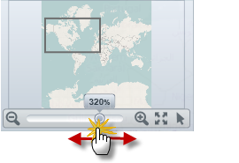
The following picture illustrates how to zoom content of the map to a specific zoom level using the zoom slider of the xamOverviewPlusDetailPane control.

GeographicMap Navigating Map Content Using Overview Plus Detail Pane 3.png

Zooming a map incrementally

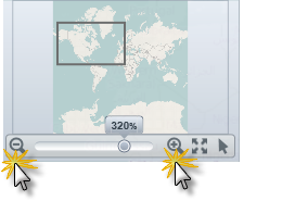
The following picture illustrates how to zoom content of the map incrementally using the mouse zoom in/out buttons located on both side of the xamOverviewPlusDetailPane control’s zoom slider.

GeographicMap Navigating Map Content Using Overview Plus Detail Pane 4.png

Resetting a map to 100% zoom level

The following picture illustrates how to reset content of the map to 100% zoom level using the zoom reset button of the xamOverviewPlusDetailPane control.

GeographicMap Navigating Map Content Using Overview Plus Detail Pane 5.png

Panning a map in all directions

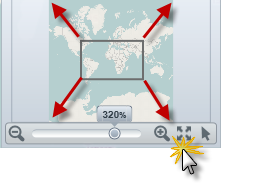
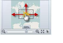
The following picture illustrates how to pan content of the map in all directions using the window rectangle of the xamOverviewPlusDetailPane control.

GeographicMap Navigating Map Content Using Overview Plus Detail Pane 6.png

Panning to a specific region of a map

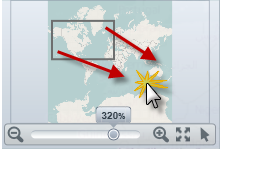
The following picture illustrates how to pan content of the map to a specific region of a map using the window rectangle of the xamOverviewPlusDetailPane control.

GeographicMap Navigating Map Content Using Overview Plus Detail Pane 7.png

Changing mouse drag interaction with a map

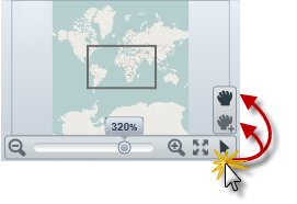
The following picture illustrates how to change a mouse drag interaction with a map using the cursor button of the xamOverviewPlusDetailPane control.

GeographicMap Navigating Map Content Using Overview Plus Detail Pane 8.png

Related Content

The following topics provide additional information related to this topic.

Topic Purpose

This topic provides conceptual information about navigating map content in the XamGeographicMap control as well as all supported navigation features of the control.

This topic provides information about navigating the map content in the XamGeographicMap control using inputs from a mouse.

This topic provides an overview of rendering geographic imagery in the background content of the XamGeographicMap control.