Visual Elements of UltraGeographicMapControl and Related Properties
Visual elements summary
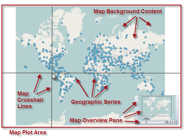
The following screenshot depicts the visual elements of the UltraGeographicMap control. Configurable elements are listed after the image.
Configurable Visual Elements:
Map Plot Area
Map Background Content
Geographic Series
Map Crosshair Lines
Visual elements and related properties
The following table maps the visual elements of the UltraGeographicMap control and the properties that configure them.
Visual Element
Description
Property
Map Plot Area
Represents an area within the UltraGeographicMap control used for plotting geographic imagery tiles and geo-spatial data using geographic series as well as displaying map crosshair lines . Background of this area can changed to any Infragistics.Win.DataVisualization.Brush object by setting the PlotAreaBackground property of the UltraGeographicMap control.
Represents an area of the UltraGeographicMap control for plotting geographic imagery tiles from supported mapping services such as Open Street Map and Bing Maps. Refer to the Using Geographic Imagery topic for more information about this map element.
Represent map elements for rendering geo-spatial vector data -points ( GeographicSymbolSeries), polylines ( GeographicPolylineSeries), or polygons ( GeographicShapeSeries) in geographic context. The UltraGeographicMap control’ Series property is a collection of geographic series objects. For more information about geographic series elements supported in the UltraGeographicMap control, refer to the Using Geographic Series topic.
Represents vertical and horizontal lines that intersect at the location of mouse cursor when it hovers over the map plot area of the UltraGeographicMap control.
This topic provides information on common usage of all types of geographic series in the UltraGeographicMap control, their benefits, and shared features.